Crowdsourcing and Open Street Maps
I think Open Street Map is going to become a really big thing. Wikipedia-like.
What Wikipedia is to Britannica, Open Street Maps is to Teleatlas (provider for Google Maps). Open Street Maps are end-user created maps. Street or park missing in your new subdivision? Just go and add it yourself - no need to wait for Google to map out your neighbourhood.
From what I’ve seen in the last 18 months, I think it will soon be the best, most current map of anywhere. When I first checked my Toronto address, maybe 18 months ago, the street was mapped, but the street name was incorrect. By about a year ago, my street was properly labelled, but the Ottawa neighbourhood I grew up in was not. Now, not only do I see Ottawa suburbs completely mapped, but I see gravel roads in cottage country properly mapped and labeled. Incredible progress in very little time.
Here’s a neat talk on information becoming accessible: http://www.ted.com/talks/lang/eng/tim_berners_lee_the_year_open_data_went_worldwide.html (shows how Haiti, which had no commercial maps at all, was completely mapped by volunteers following the earthquake).
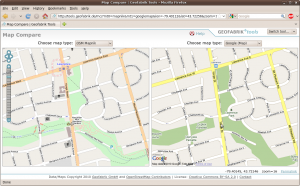
Now, the Open Street Map map of my neighbourhood is far better than Google’s. See how the walking trails are mapped near Yonge and Lawrence in the Open Street Map: http://tools.geofabrik.de/

The map data is there, but the open tools aren’t quite there yet. You can download the raw maps, but the software to view them is still pretty simple. Also, easy to use routing / directions just isn’t there yet…